13 October 2018•Update: 14 October 2018
By Muhammad Latief
JAKARTA
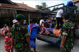
Nearly two weeks after a 7.7-magnitude earthquake struck the city of Palu and its surrounding areas in Central Sulawesi, Indonesia, the death toll has risen over 2,000.
The quakes, followed by liquefaction, left Central Sulawesi in ruins, especially Palu, which was hit by tsunami waves as high as seven meters. Satellite data showed over 3,000 buildings were destroyed.
Experts concluded that the high number of fatalities and massive damage were caused by of several factors, such as a vulnerable spatial plan, lack of public education about disaster response and failure of early-warning detection systems.
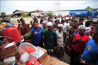
Head of the Information Data and Public Relation Center of the National Agency for Disaster Management, Sutopo Purwo Nugroho said that around 5,000 people are feared to be buried under debris in and Petobo regions.
They were living in 1,445 housing units in and 2,000 housing units in Petobo. After severe multiple quakes, these neighborhoods were essentially wiped off the map.
This phenomenon, causing most of the damage, is known as liquefaction, when the soil loses its strength to support structures due to a sudden stress such as an earthquake.
The ground lost its strength and turned into mush and created mud which moved like quicksand and squeezed the water. As the water pressure got built, the land moved and buildings sank into the land.
The tsunami hit the city as hundreds of people gathered on Talise Beach for the 40th anniversary of Palu.
Officials had estimated that about 50 people could be trapped under the rubble of the collapsed Roa-Roa Hotel. Evacuations have been carried out in other buildings such as the Sa Hotel, the Mercure Hotel the Tatura Mall.
But due to many obstacles, the government is considering designating liquefaction areas as mass graves. This measure is considered the best option to avoid wider environmental and health problems.
- Learning from Palu quake Palu is located on the Palu-Koro fault, which runs across Sulawesi Island. The head of the Indonesian Institute of Sciences (LIPI)’s Geotechnology Research Center Eko Yulianto told Anadolu Agency that geologists paid great attention to the faults since they had been very active.
Data from the Geological Agency show that Palu is located at the junction of the world's three main tectonic plates -- Indo-Australian, Pacific Eurasian.
According to experts from LIPI, the natural phenomenon in Palu needs more attention due to the mechanism of the horizontal fault structure movement.
LIPI also mentioned a possibility that faults on the Koro Hammer had a vertical deformation component on the seabed which triggered the tsunami.
"Lessons learned. We need more thorough geo-scientific data in order to assess that under the ocean," Yulianto said.
A joint Indonesian-Japanese team revealed that the tsunami came ashore about 10 minutes after the earthquake, but people did not have enough time to evacuate.
The Geological Agency actually had warned about the possibility of a tsunami and the dangers of liquefaction in Palu.
Risna Widyaningrum, a researcher from the Geology Agency who also spoke to Anadolu Agency, named several areas with high liquefaction risk: Kalukubula, Birobuli, Tatura, Sunju, Tatura, , Kawatuna, Lere and South Birobuli.
Widyaningrum said that areas with high liquefaction risk should not be designated for residential, industrial and other vital buildings, adding that buildings in such areas must meet safety standards.
The researchers also suggested that the coastal city of Palu should be uninhabited.