
In the high Himalayas, a flood does not always begin with rain.
It can begin with a glacial lake suddenly bursting, a mountainside collapsing or an avalanche of ice and rock crashing into a river. In the steep Himalayas, one hazard can rapidly trigger another, ultimately sending a destructive flood downstream.
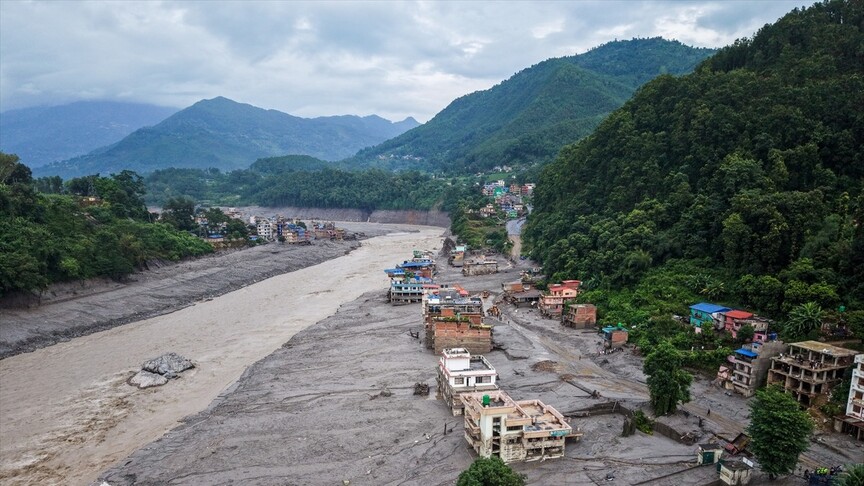
Scientists are investigating exactly what happened Wednesday, when a major flash flood struck the Nepal-Tibet border region, sending water, sediment and huge boulders downstream through Nepal's Rasuwa district and affecting Kyirong in Tibet.
The speed was extraordinary. Water levels on the Trishuli River at Galchhi rose by as much as nine meters (30 feet) in just 30 minutes, according to the International Centre for Integrated Mountain Development (ICIMOD).
Preliminary investigations suggest an ice-rock avalanche originating from a glacier on the north side of Langtang-Lirung mountain plunged into the Lhende Khola river near the Nepal-China border.
The collapse was so powerful that it caused a seismic signal first reported as a magnitude 4.4 earthquake but later reclassified by the US Geological Survey as a magnitude 5.2 landslide.
For Mohan Bahadur Chand, a Himalayan glaciologist at Kathmandu University who was among the first scientists to identify the suspected trigger, the disaster illustrates a fundamental challenge facing the region – floods that look similar when they reach populated valleys can begin in very different ways high in the mountains.
"Always when we are having this type of floods, they have a different nature, different origin in nature, different mechanism in nature," he told Anadolu.
Same place, different disasters
That challenge is particularly stark in Rasuwa, a mountainous district about 160 kilometers (99 miles) north of Kathmandu that includes a major border crossing with China.
This is the second time in just over a year that the same border region has been struck by a major flood. But scientists believe the two disasters had different origins.
In July 2025, a sudden flood swept down the Lhende River and into Nepal, killing at least 11 people and damaging bridges, hydropower facilities and other infrastructure more than 100 kilometers (62 miles) downstream.
A post-event investigation found that disaster was caused by the rapid drainage of a supraglacial lake – a body of water that forms on top of a glacier – on China's Purepu Glacier.
Nepal alone has more than 2,000 glacial lakes, including 21 identified as high-risk in a 2020 ICIMOD assessment. Thousands more are scattered across the wider Himalayas, including in neighboring China and India.
Wednesday's flood appears to have a completely different source.
Chand's preliminary assessment points to an ice-rock avalanche that plunged toward the river, gathering debris, sediment and boulders along the way.
The debris may then have temporarily blocked the river, allowing water to build up before the barrier breached, though he stressed that the exact sequence has not yet been confirmed.
ICIMOD scientists and partners in Nepal and China are investigating a similar scenario, while also analyzing seismic, hydrological and remote-sensing data to establish what happened.
For disaster preparedness, determining the cause is crucial.
A system watching for heavy rainfall or rising river levels may provide little advance notice if the event begins instead with the sudden collapse of ice and rock high above a river.
And Chand said the problem extends across the Himalayas, where major floods have been triggered by glacial lakes, landslides, avalanches and other processes.
"Not only in Nepal and the different parts of the Himalayan regions … different mechanisms, different process, those are triggering such big floods," he said.
When 1 hazard becomes another
The difficulty is compounded by the way one mountain hazard can rapidly transform into another.
An ice-rock avalanche can pick up sediment, boulders and water as it travels downhill, becoming a debris flow or flood far larger and more destructive than the initial collapse.
The 2021 Chamoli disaster in India's Uttarakhand state offered a devastating example. A huge mass of rock and ice broke from a mountain slope and transformed into a fast-moving debris flow that destroyed hydropower facilities and bridges, killing more than 200 people.
Early reports incorrectly described it as a glacial lake outburst flood.
Researchers later found that warning signs of the ice-rock avalanche had been visible in remote-sensing records before the collapse but were not detected and acted upon in time.
The case exposed a wider weakness in Himalayan disaster preparedness, according to a study published this year in Communications Earth & Environment – glacial lake floods, landslides and avalanches are often assessed separately even though one hazard can transform into another within minutes.
Chand added that a fundamental problem is how much remains unknown about conditions in the mountains, calling for greater research and monitoring of glaciers, permafrost and glacial lakes.
The work is "physically challenging" and resource-intensive, he acknowledged, but said governments, scientists and other stakeholders need to prioritize understanding what is happening in the mountains before disasters strike.
There is evidence that monitoring can save lives even when the hazard itself cannot be prevented.
In May 2025, authorities evacuated around 300 residents and their livestock from the Swiss Alpine village of Blatten after monitoring detected accelerating movement on a mountainside. Nine days later, a massive glacier-rock avalanche buried nearly 90% of the village's built-up area. One fatality was reported.
But replicating such intensive monitoring across the Himalayas would be far more difficult because of the region's enormous scale, rugged terrain and limited access to many high-altitude areas.
Rasuwa presents another complication: the hazards themselves can cross international borders.
ICIMOD's water and disaster risk reduction lead Neera Shrestha Pradhan said the disaster underscores the need for cross-border early warning systems so information from upstream areas can reach communities downstream in time for them to act.
Is climate change making the danger worse?
The hazards are varied, but they are unfolding in a mountain environment being transformed by a warming climate.
Warming is accelerating glacier melt across the region, contributing to glacier retreat and the formation and expansion of glacial lakes – changes that can alter conditions in the high mountains and the risks facing communities below.
Chand cautioned, however, against drawing a direct line between climate change and Wednesday's flood before scientists establish precisely what triggered it.
"Yes, somehow we can say, there might be not a very direct relationship," he said. "If we know the temperature is increasing, then the melting pattern of those glaciers is also accelerating."
A July 2026 study co-authored by Chand mapped glacial lakes across Nepal and neighboring transboundary catchments from 2017 to 2024 using satellite imagery and deep-learning methods.
It found rapid growth in glacial lakes, particularly in the Koshi basin, which includes river systems shared by Nepal and China. The researchers said the findings could support long-term monitoring of glacial lakes and efforts to reduce the risks they pose.
But warming is only one part of a highly dynamic mountain system.
The Himalayas are also geologically young and tectonically active, with unstable slopes susceptible to earthquakes, landslides and rockfalls. Those underlying geological conditions can interact with changes in ice, snow and permafrost to create complex and sometimes cascading hazards.
Chand also mentioned the contribution of other human factors such as construction, though that is less likely for events that are set off at extremely high altitudes.
What happens next?
The immediate danger in Rasuwa is not over.
Debris from Wednesday's disaster formed a barrier lake upstream near the Nepal-China border. By Friday, it held more than 2.5 million cubic meters of water, up from an estimated 1.5 million-2 million cubic meters a day earlier.
Chinese authorities deployed an engineering team to conduct aerial surveys and 3D modeling of the lake as officials monitored the risk of another sudden release of water.
The threat has already affected the response downstream. Rescue teams in Nepal temporarily withdrew Friday as the Trishuli River began rising again, while residents in Rasuwa and other areas were urged to move to higher ground.
Chinese rescue personnel also temporarily pulled back from threatened areas.
Chand had spotted signs of the new lake in satellite imagery when he spoke to Anadolu, warning that continued accumulation of water could lead to another breach.
However, he did not expect another surge to necessarily match Wednesday's disaster.
"But there might always be a chance, there is always probability,” he said.
Beyond the immediate threat, Chand said the larger challenge is understanding the rapidly changing mountains well enough to identify such dangers before they become disasters.
"Knowledge itself from the mountain, glaciers, permafrost, glacial lake is still not enough," he said.
news_share_descriptionsubscription_contact

contact_the_ombudsman
is_there_an_error_in_this_story